Car Free Zion National Park, UT

The most popular of Utah’s five national parks, Zion is also the only one easily reachable without a car. Unlike many other canyon parks, such as the Grand Canyon, the main road and trails run along the canyon floor, allowing you to take in views of towering red rock walls without an exhausting multi-day hike.

  1. Fly to St. George or Las Vegas.

The St. George,UT airport will be pricier, but you also need to factor in the additional shuttle cost from Vegas to St. George and the two hours each way you will lose sitting on the shuttle.

  1. Take St. George Shuttle to Springdale/Zion.

St. George Shuttle from Vegas to St. George will cost $50-78 roundtrip, and from St. George to Springdale will cost $40 roundtrip. They offer two daily trips to Springdale.

  1. Lodging in Springdale/Zion National Park

Zion Lodge is the only in-park lodging in Zion and is extremely expensive. Even the cheapest room in the off season will set you back over $200 per night. There is a campsite accessible via the park shuttle for $20 per night, but you will need to make your reservations WAY in advance as they book up fast. My husband and I stayed in the Canyon Vista Lodge in Springdale, which is a little pricey for someone who is used to budget hotels, but was a deal the holiday weekend we went when all other rooms both in the park and in Springdale were either booked or over $250 per night. And the rooms were larger than my apartment! Around 600 sq. ft, with breakfast included and kitchenettes.  If you do stay in Springdale, look for lodging within walking distance of Highway 9 and the shuttle bus stops there. However, Springdale is not that big, so most lodging should be safe.

  1. Take free Springdale Shuttle into Zion National Park.

Zion’s shuttle system operates from early March until November.  When it’s running, you in fact have no other option to access the main canyon, as the park rangers close it off to all traffic but the shuttle buses due to congestion that previously plagued the canyon. If you want to go to the more remote Kolob Canyons area you will be out of luck, since that is only accessible by a 45-minute car ride.

Because we went in winter in a car, and the park rangers closed the main park entrance down at 10 am one of the two days we were there, we spent 90% of time in the Kolob Canyons area and hiking other trails that are only accessible by car, so I can’t really give many firsthand suggestions for hikes to do. In winter, many of the best hikes like the Narrows or Angels Landing are also unpleasant to dangerous because of temperatures and ice. However, we did manage to get in the Riverside Walk to the Narrows. It was very pretty, but more experienced hikers may want to choose another trail since the ease of this trail makes it a popular choice for people with strollers/small children and it was extremely crowded even in winter.

Copy of P1120717

Riverside Walk


Copy of P1120697

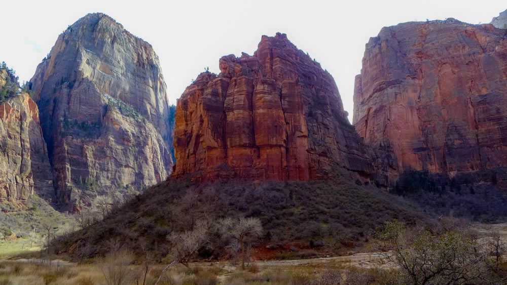
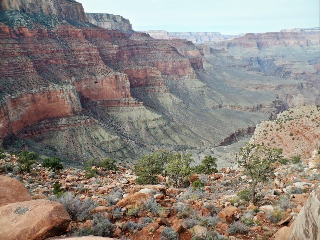
Canyon floor on the shuttle bus route
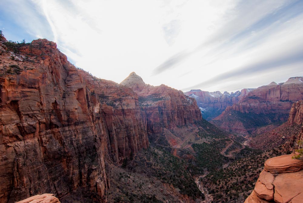
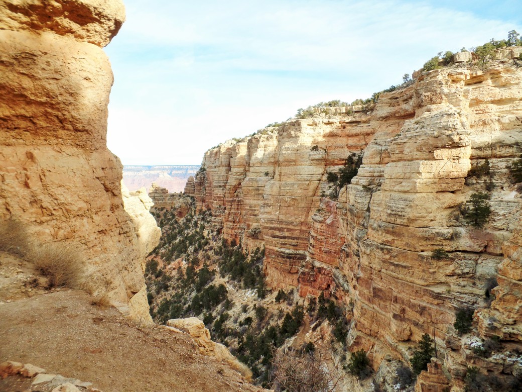
Copy of DSC_0198

Canyon Overlook

Car Free Huntley Meadows Park, Alexandria, VA

“I had no idea this was here!” is the most common reaction when I bring friends to this park in the middle of otherwise urban Alexandria. The 1,500 acre Huntley Meadows is a large marsh that contains some of the only wetlands left in Fairfax County. The park is an animal lover’s paradise with beavers, turtles, lizards, deer, and over 200 species of birds, among others.

SAMSUNG CAMERA PICTURES

Huntley Meadows in November

To get to the park, take Metro to either Old Town or Huntington Station. From there, take the Metrobus labelled REX (Richmond Highway Express) in the direction of Fort Belvior. Get off at the Richmond Hwy and Lockheed Blvd stop. Walk past the CVS on Lockheed Blvd about 3/4 of a mile to the end of the road where it meets Harrison Lane. The park entrance will be on the left side of the road with a big sign that’s hard to miss.

The Heron Trail boardwalk is the prettiest walk in the park if you only have a short time, but the other two trails, the Deer and Cedar trails, are fairly short, and all three trails combine to make a 2 mile loop. If you budget about an hour and a half to stay in the park there’s no reason you can’t do them all.

SAMSUNG CAMERA PICTURES

Fall colors

SAMSUNG CAMERA PICTURES

Beaver lodgings

SAMSUNG CAMERA PICTURES

Heron Trail boardwalk

SAMSUNG CAMERA PICTURES

Late afternoon cloud reflections

SAMSUNG CAMERA PICTURES

Some of the park’s birds and turtles


Car Free Grand Canyon National Park, AZ

It’s probably the most famous national park, but did you know that the Grand Canyon is also accessible by public transport year-round, even in winter?

1 . Fly/Amtrak to Flagstaff, AZ.

Amtrak also goes to Williams, AZ, where you can transfer to the Grand Canyon Railway at the station, and take that into the park. However, I chose to take a shuttle from the airport because the GCR was more expensive and would also have required me to drag my suitcase through the park to my lodging.

2. Shuttle from Flagstaff Airport/Amtrak to Grand Canyon. 

Arizona Shuttle runs 2-3 shuttles daily from Flagstaff to the Maswick Lodge in the park. It picks up at the airport and the train station, and costs $28 each way. It will also drop you off in the gateway community of Tusayan, which is connected to the park by a shuttle that only runs during the summer months.

3. Stay at the Maswick Lodge. 

This is the cheapest of the in-park lodging options, and has a park shuttle stop and a cafeteria located right next door to it. This is also the park drop-off point for Arizona Shuttle. Warning: some of the rooms in the Maswick have no AC, which I believe is the main reason they are cheaper than the other lodging options since the rooms are otherwise perfectly decent. Since I went in January, this wasn’t an issue for me, and their heat is fully functional.

4. Park Shuttle System

This is the only national park I’ve found that has a year-round shuttle within the park (though some of the island ones have year-round ferries). In winter, only two routes were running- the Blue Route that connects the park lodging facilities, parking, and visitor center, and the Orange Route to the South Rim overlooks and trailheads. From spring to fall, the park adds an additional route to scenic overlooks in the opposite direction of the Orange Route, and in summer only there is a shuttle bus to the gateway town of Tusayan, which opens up more lodging options for car-less travelers.

5. Day 1: South Kaibab Trail and Rim Trail to Hermit’s Rest

In the morning I took the shuttle bus to the South Kaibab Trail and hiked down into the canyon, about a half mile past Cedar Ridge. Since it was January, there was a little bit of snow and ice on top of the trail, but not enough to pose a substantial slipping hazard if you go carefully. As many signs will warn you, the hike back up is very strenuous, so the comparatively short mileage is highly misleading. I’m VERY glad I was not hiking this in summer.

SAMSUNG CAMERA PICTURES

View near the top

SAMSUNG CAMERA PICTURES

Looking down into the canyon

SAMSUNG CAMERA PICTURES

First turnaround point

SAMSUNG CAMERA PICTURES

Burro rides are also available if you don’t feel up for the steep hike

SAMSUNG CAMERA PICTURES

The South Kaibab trail headed down the canyon- I love the contrasting rock colors!

After taking the shuttle back to Maswick Lodge, I followed the Rim Trail on the edge of the canyon away from the lodging area and shuttle bus routes for sunset. This is the path that the Red Route of the shuttle bus follows when it is running, but it is an easy hike to do without the aid of a bus. Depending on the time of day you look at the canyon, the rocks always appear different colors. The sunset made the colors morph to shades of pink, purple, and green.

SAMSUNG CAMERA PICTURES

Colors as the sun was setting

SAMSUNG CAMERA PICTURES

About ten minutes after the sun went down behind the canyon

6. Day 2: Rim Trail and Yaki Point

The second day I ditched the shuttle bus and walked the Rim Trail from Bright Angel Lodge to the South Kaibab trailhead. I also did a tour of Kolb Studio along the way that is only available in winter due to the summer crowds. The studio hangs off the edge of the canyon and was one of the earliest tourist businesses there. It was fascinating seeing how the two owners managed to film a movie of themselves going down the Colorado River in 1911!

SAMSUNG CAMERA PICTURES

Kolb Studio

Walking along the Rim Trail, there were some breathtaking viewpoints that you would miss out on if you just took the shuttle from stop to stop, and was a very easy, mostly paved, path. After I reached the end of the trail, I took the shuttle to Yaki Point and did a little hiking on the trails before watching sunset.

SAMSUNG CAMERA PICTURES

Rim Trail

SAMSUNG CAMERA PICTURES

Rim Trail

SAMSUNG CAMERA PICTURES

Cloud shadows in the late afternoon

SAMSUNG CAMERA PICTURES

More cloud shadows across the canyon

The next morning, I woke up to catch the sunrise colors on the canyon and then took the shuttle back for my return flight to the airport. Overall, I would highly recommend going in winter like I did. The temperatures were perfect for hiking, in the low 60s and high 50s, as opposed to the summer, when it can reach 100 near the canyon floor, with monsoon rains in July and August. Additionally, even on a holiday weekend, the crowds were light in January, and the lodging costs and flights were cheaper than during other times of the year. The only downside is that one of the shuttle lines doesn’t start running until March, but the route is easily walkable if you absolutely have to see it.

SAMSUNG CAMERA PICTURES

Sunrise red colors on the rim

Car Free Dry Tortugas National Park, Florida

Dry Tortugas National Park, located in the Gulf of Mexico 70 miles off of Key West in Florida, may have the distinction of being the only national park in the U.S. solely accessible by public transportation (unless you are willing to shell out megabucks for a private boat or plane charter). For obvious reasons, this is also one of the least visited U.S. national parks, with only around 60,000 visitors per year.

1. Fly into Key West. 

If you would like to fly into Miami instead to try and save money, there is also a shuttle that can take you from there to the airport, but at least when we booked it, flying into Key West directly was only a little bit more expensive. Greyhound goes to Key West, but unless you already live in South Florida, it is really only an option for people who have unlimited time.

2. Taxi/walk/bike to the ferry terminal. 

The island of Key West is only 4 miles long by 1 mile wide, so you should have no trouble getting around. Bike rentals are readily available throughout the town.

3. Take the Yankee Freedom III ferry into the park.

The ride will take about 2.5 hours each way, with four hours on the main island of Garden Key for sightseeing. Free snorkel equipment is provided, which I highly recommend taking advantage of!

4. Explore Fort Jefferson. 

The Dry Tortugas were a U.S. military base location for much of the 19th and early 20th centuries. Fort Jefferson is an unfinished brick fortress and the largest masonry structure in the Western Hemisphere.

P1010703 (2)

A small portion of Fort Jefferson

Fort-Jefferson_Dry-Tortugas

Photo credit: U.S. National Park Service

5. Snorkeling!

Hawaii isn’t the only place in the U.S. where you can see coral reefs! The Dry Tortugas have the most undisturbed coral in Florida. The coral reefs around Garden Key take a little effort to find, since you will be going off a paper map that the ferry operators give you without any markers once you get in the water, and no guides to help you. No one else in our tour group bothered with the effort, but by carefully following the angles on the maps that tell you where to swim from the side of Fort Jefferson, we were able to find the reefs after about a half hour of hunting, and were rewarded with beautiful tropical fish. If you’d rather take it easy, many fish also hang out along the seawall of the fort.

Submerged_artifact_at_Dry_Tortugas_NP

Photo credit: U.S. National Park Service. We forgot our underwater camera 😦

Car Free Congaree National Park, South Carolina

Congaree National Park is one of the newest and least well-known parks in the U.S., despite being one of the few national parks on the East Coast. It preserves the largest area of lowland old growth forest left in the U.S., and the tallest trees of several species are found here. The Congaree River that runs through the middle of the park floods multiple times a year, which saved the area by making it too difficult to log, unlike most of the forests in the Southern U.S.

Full disclosure: I went with a friend in her car since plane/Amtrak costs were astronomical the July 4 weekend. However, this park is still doable with public transportation.

1. Fly or Amtrak into Columbia, South Carolina.

Of these two options, Amtrak is the slightly easier one for those on the East Coast that will be able to take it without burning too many hours on the train. The Amtrak station is in the middle of downtown, as opposed to the airport, which is outside the city limits in the wrong direction to go to the park. If you take Amtrak, the line to Columbia will likely allow bikes aboard the train.

2. Bike/Taxi/Uber to Congaree.

Biking is definitely the most cost-effective way to get to the park, and at 18.5 miles from the city center is a doable ride. However, the route to get to the park from Columbia is a highway with no shoulders or bike lanes, so this could be a slightly dangerous option. Using Uber, the cost to the park from downtown will be around $30 each way, or a little more with a taxi. Once you are at the park entrance you will have no trouble getting around on foot- the park is not that big and vehicles are actually not allowed in at all.

3. The Boardwalk Trail

This trail is the first one we did, and is the star attraction of Congaree. The trail is entirely on a raised boardwalk to avoid the muddy/flooded ground, and the terrain looks like it has come straight out of Jurassic Park. The trail is 2.5 miles roundtrip, and is an easy stroll. The only downside when we went was that some sections of the boardwalk were closed due to flood damage, which seems to be a common problem no matter what time of year you go.

SAMSUNG CAMERA PICTURES

Don’t forget your bug spray! 

SAMSUNG CAMERA PICTURES

Boardwalk Trail

SAMSUNG CAMERA PICTURES

Flood damage

SAMSUNG CAMERA PICTURES

A few sections of the park were still underwater

4. Other trails

Thinking that if the very easy Boardwalk Trail was so good, the other, more rugged trails must have even better scenery, we ventured out onto parts of the Bluff Trail and Oakridge Trail. Unfortunately, while the scenery was still nice, it was pretty monotonous and not as dramatic what we saw from the boardwalk. The trails were also not that well marked, making us uneasy that we were walking the wrong way. A friend we went to dinner with the next night told us that she met her Congaree park ranger boyfriend after getting lost on the trails and calling for help, and that he usually has to rescue lost hikers every weekend!

We were hoping to see the wild pigs that the park was known for, and could even hear them snorting in the distance, but never managed to actually find them, and saw no other wildlife besides a few centipedes and lizards. Overall, we wished we had just spent more time on the main boardwalk.

5. Canoeing/camping

The park’s canoe trails are also very famous, but without a  car, you’ll be hard-pressed to figure out a way to get one to the park. Luckily, the park rangers offer guided canoe tours on several weekends throughout the year, with all canoes and equipment provided! These are very popular, so if you’re interested, book well in advance. If you want to stretch out your visit, you can also camp near the front entrance.

In my opinion, this park is better suited for a day trip, but combined with some of the destinations in Columbia, like the State Capitol, it can be a fun car-free weekend destination.